
A project that has been in the works for about a decade – the first step in an interconnected Wrangell trail system – is nearly ready to be built. But engineering a new trail down a small mountain, across woodlands and wet muskeg is a big job.
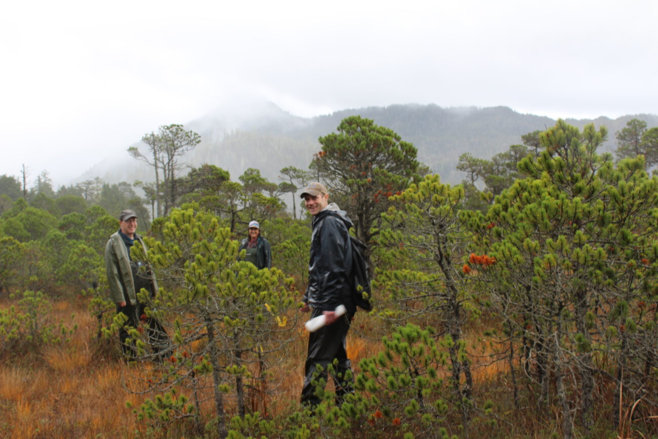
It’s a typical Southeast autumn day – whipping wind, driving rain – as a small group gathers at the base of Mt. Dewey, above downtown Wrangell.
The existing Mt. Dewey trail snakes in a curve, shaped sort of like a foot, around the side and up the back of the hill, ending at an overlook platform set above town.
Wrangell Capital Facilities Director Amber Al-Haddad introduces the trail expansion project as a small group starts the hike up the forested hill.
Al-Haddad explains Wrangell has a Federal Lands Access Program (FLAP) grant of just over $904,000 to expand the trail system by three-quarters of a mile. It will extend the trail down the backside of Mt. Dewey, across a muskeg, and connect it to the road that loops between the airport and town.
Much of the existing Mt. Dewey trail is what’s called “step-and-run,” a style of boardwalk trail. Juneau-based landscape architect Christopher Mertl, with Corvus Design, says community feedback on a trail extension was clear: less boardwalk.
“A lot of trail agencies are getting away from this type of trail just because it is very slippery,” Mertl says, “And they’re actually making trails longer so that they can use gravel. But because we already have step-and-run here on Mount Dewey, it’s also cost-effective and pretty quick to bang in. The intent is to use step-and-run from the backside of Mount Dewey till we hit the muskeg, creating a little bit of trail continuity.”
And project engineer Brandon Ivanowicz says the team is thinking about how to reduce the slipperiness on the boardwalk portion of the new trail.
“There’s a couple of ways we will mitigate that,” Ivanowicz explains: “We’ll use a rough-sawn cedar board that’ll have some traction just by the rough sawing process. And then we’ll also do some sort of mechanical non-skid on top of that being either a stapled seine net or a stapled wire mesh, just to give that little bit of extra traction on the top surface.”
The Mt. Dewey trail extension has been in the works for years, since the community first secured a National Park Service technical grant. That led Wrangell to develop a sustainable outdoor recreation plan, including ideas for trail expansion headed by trail consultant Mike Shields.
Mertl, with Corvus Design, and PND Engineers out of Juneau were hired in the spring of last year to complete the project, based on plans that came out of that grant in 2014. Mertl says there’s a lot of thought, planning, and engineering that goes into putting in a trail on a fairly wild hillside and across a muskeg.
“You’re looking at terrain, natural features, you want to try to get a trail that has a level of difficulty, steepness, and look at the materials so that it matches your anticipated user of the trail,” Mertl says, “But you also want to make sure you have a good user experience, that you get to experience the landscape and cool things along the way, so all that kind of comes together.”
But, Mertl continues: “Our marching orders were to largely follow what had previously been done in the community and just tighten it up and clean it up a little bit and move away from the boardwalk down into muskeg.”
Mertl says that includes a fair amount of footwork – literally – placing flagging tape one way, backtracking and editing the path, adapting and changing until it has the right feel.
“You walk it many, many times to get the feel for the land and see where the trail lays in nicely,” he says.
Asked to ballpark how many times he’s walked the path, Mertl gestures to the ground and responds: “Put it this way: there were probably no footsteps here or trail here when we started. So you can see there’s a pretty good trail established.”
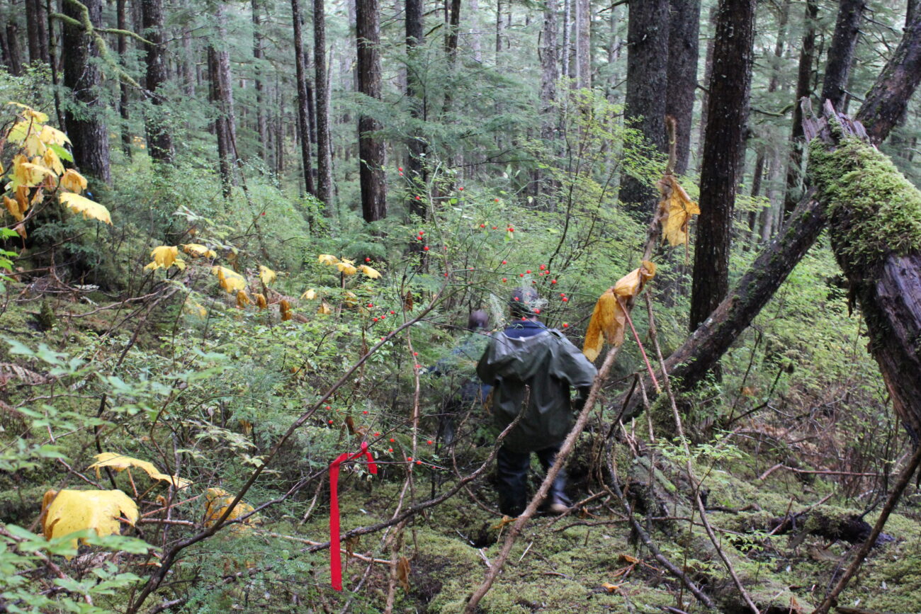
There’s also a rainbow collection of flagging tape along the brushy path – red, blue, orange, pink. Mertl says he mostly made notes in red.
Sometimes, the process is intuitive. Al-Haddad refers back to the well-worn trail Mertl pointed out.
“As you leave that boardwalk, you can see it’s fairly flat,” she says. “We were able to easily pick a line to follow across the slope here. Then the next hard part was just figuring out where to transition to the next level down below, so it was a lot of poking around, and: ‘Well maybe through here,’ ‘Well, no, there’s a big tree, that doesn’t work. We don’t want to cut that one down.’ There are just a lot of ‘What ifs?’”
Two-thirds of the new trail will be aggregate – or gravel – and the rest step-and-run timber trail.
Further down the side of Mt. Dewey, the path isn’t clear, save for the flagging tape. Yellowing devil’s club and thick moss cover the ground, beneath the typical Tongass mix of hemlock, Sitka spruce and yellow cedar. There’s a fair amount of scrambling.
“This section actually is one of three small staircases we have,” Mertl says, on a particularly sheer section. “It starts to get really steep over there, so we have to come down and pick up our next traverse going in the opposite direction, so there is a small staircase through here.”
Community member Keith Appleman brings up the back of the small group. He’s no stranger to trail planning – he worked for more than two decades in trails with the U.S. Forest Service and local tribal government.
“You’ve gotta get to the bottom some way,” Appleman says with a smile, standing by a fallen log. “Side hills are always hard because everything you put – boardwalk, etcetera – you’ve got to support the outside side. And everything naturally just wants to creep downhill. So the side hill is always tough.”
After a bit of slipping and sliding under and over logs down the V-shaped switchback to come off Mt. Dewey, the ground levels.
“Now that we’ve come off the backside of Mount Dewey and that side slope, this is where we change the trail into gravel. We’ve got gentler, flatter slopes through here,” Mertl assures the group.
Another minute of walking, and the forest breaks. The ground begins to have the characteristic muskeg squelching, and trees thin into scrubby lodgepole pines and other muskeg brush. This is where the traditional gravel trail will transition into what’s called “geocell.” Mertl explains it’s a trail material that will help the trail sort of float over the muskeg.
“The idea is that geocell distributes the weight of the trail and keeps it separate as a matrix away from the organics,” Mertl says. “It just floats as one unit and then it’s got cedar edging on either side: peeled cedar posts, and then 12 inches of gravel. The idea is that floats – it does slowly sink over time – but the idea is it creates a level easier walking surface, easier maintenance and because it’s gravel, it’s not slippery.”
As for exactly how much of the trail needs to be “floated”?
“Any time you hear: ‘Squish squish squish,” Mertl says with a laugh.
That’s about a third of the trail, or a quarter of a mile.
Through parts of the muskeg, and leapfrogging in and out of forested clumps, the trail has been moved 12-15 feet from the original plans to get it into more stable soils and closer to the city right-of-way between lots. Designers have also accounted for all the tiny drainages and waterways through the muskeg.
“Obviously here when you’ve got a trail going across a drainage, it can create a dam,” Mertl explains, his feet at the edge of a small stream of running water. “So in these cases you put some culverts and get the water to flow through.”
There’s also at least one point where there will need to be a small footbridge to cross some running water. Ivanowicz says it’ll be made of laminated timber and probably too short to have handrails, just small curbs.
As part of the process to design the trail extension, Wrangell has had to seek approval from the United States Army Corps of Engineers and do some of what’s called “compensatory mitigation” for the impact to the wetlands – that’ll cost about $24,000.
This muskeg isn’t entirely pristine wilderness, though. It’s already used by locals for motorized recreation. Appleman points out broken-off branches placed over a stream as a makeshift bridge.
“You can just see where they put the logs and stuff put down over the drainage, [that’s] from local people that snowmachine and run four-wheelers out here,” Appleman says. There are also ATV tire tracks crisscrossing the muskeg grasses.
Back in 2014 during public listening sessions, Wrangell residents expressed serious concerns about how a trail could impact snowmachining and other motorized recreating in the muskeg areas. The trail funding is focused on non-motorized transport, but Mertl says they’re doing the best they can to accommodate everyone who ventures out into the muskeg.
“The trail that we’ve laid in is pedestrian, and isn’t following the same circulation patterns as the snowmachiners or the ATV users,” Mertl says, “But there are places where they cross, so we’re looking to build up the trail in those areas so that in times that there’s maybe not enough snow, that when the machines go up and over the trails, that they’re not degrading the edges so much, and trying to reduce some of the impacts to the wetlands.”
“The trail is not designed for motorized use,” he adds, “But there are three places where [established motorized trails] do cross [the new trail plan].”
Other parts of the planned trail route have already been used for non-motorized access as well.
“There was a fairly well-worn game trail, pedestrian trail through here,” Mertl says while passing through an especially thick clump of trees, “So people are coming in into these meadows, we know that. Obviously by putting in a hardened trail we’re going to reduce the impacts and the degradation of the wetlands and just make it easier for people to come here and making the link to the Mount Dewey trail is just a logical connection for creating a trail network for the community.”
The new trail will also allow for future expansion. Partway through the muskeg, we make a turn, and Mertl stops again.
“This is what’s going to be a larger arterial trail that connects Bennett [Street] or Airport Road that’s going to run all the way over to Petroglyph Beach,” Mertl says. “But right now, we have funding to take it to this point and run it up to Dewey.”
That arterial trail will also be wider – 6 feet across – to accommodate heavier foot traffic and bicycles. Once the trail extension over to Petroglyph Beach is finished, the whole section cutting across Muskeg will be wider.
“It was a balance between impacts to the wetlands,” Mertl explains, “Because you have to put in for a[n Army] Corps permit, available funding, who are your users, you’ve got to balance all that.”
And then – the road. Bennet Drive, also known as the Airport Loop.
This is where the trailhead and a small (5-car) DOT-approved parking lot will be, Ivanowicz explains.
(Sage Smiley / KSTK)
“There’ll be a little bit of wayfinding signage for the trailhead, to route along the trail and then up to Mt. Dewey,” Ivanowicz says, “Then there will be a few site amenities: a bear-proof trash can, a dog poop bag dispenser, and there’ll be a little park bench too.”
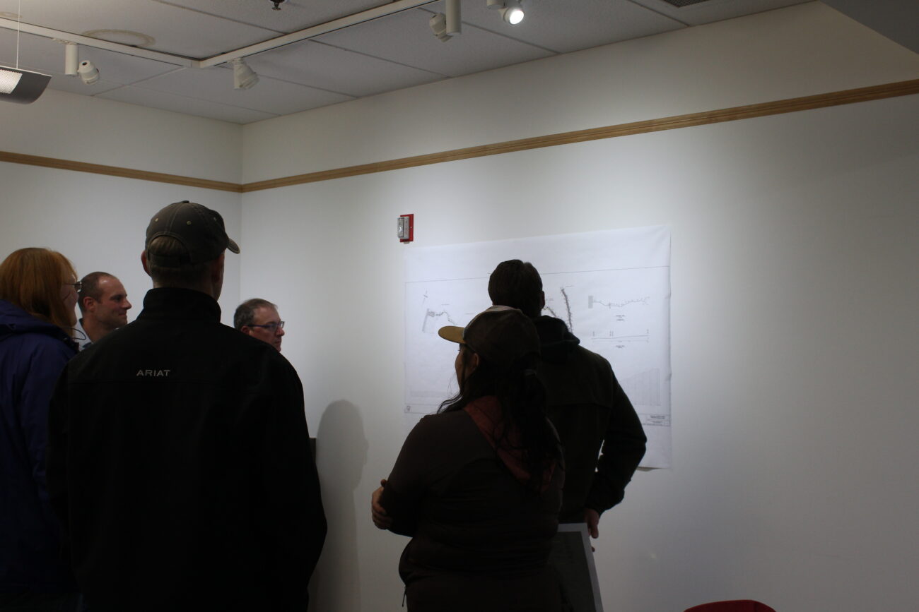
At a public meeting after the trail walk-through, Wrangell Mayor Patty Gilbert expressed excitement about the trail extension and came with questions. One topic she focused on was accessibility for tour groups during the summer season.
“We do have a lot of traffic on the trail as it is with cruise ships coming in,” Gilbert said, explaining she worried the small parking lot might not be able to accommodate a burgeoning small-boat visitor economy in Wrangell.
“Can tour bus, for instance, navigate in? And would they just have to back up into the highway, or would it be possible for them to turn around if there’s cars parked there?” she asked.
Engineers said they could work a bit more on widening the spaces. Plus, they added, the parking lot will be gravel – no lines painted. An occasional bus would probably be able to navigate just fine.
The total project cost is projected to be just over $1 million. That includes a short trail connecting the Volunteer Loop nature trail behind the elementary school to Ishiyama Drive, also known as Spur Road. Most of the funding will come from the federal land (FLAP) grant, along with around $100,000 from the borough, and an in-kind match from the Forest Service of about $34,000 in labor.
P&D engineers expect to have the 95% design done by November 25. The borough would put the project out to bid in December or January, hoping to have a contract in place by spring. Then construction would follow next summer.
Even with global supply chain issues, Ivanowicz says they expect to be able to stick to that quick building schedule.
“The materials – there’s some geotextile fabric, there’s a little bit of pressure-treated wood, but most of the materials are aggregate [gravel] and yellow cedar that’s available here in town locally, so not a lot of lead time,” he says. “Really, once the contract gets in place, some contractor will be out here right away. We expect an early spring start.”
Al-Haddad says there have been years of planning, waiting, and revising to make this trail extension a reality: “In the end, if we construct by this next summer (2023), it will have been a 10-year planning and construction project.”
In the world of capital projects, Al-Haddad says it’s actually a fairly average timeline. And, it’s worth the wait to find proper funding and do the process right, to let Wrangell trail users experience a bit more of the forest and wetlands just outside their doors.
Get in touch with KSTK at news@kstk.org or (907) 874-2345.


