
State geologists in early February published their final findings on the Wrangell landslide that killed six people. They found that the November 20th slide was caused by excessive amounts of rain in a short period of time – even for a rainforest.
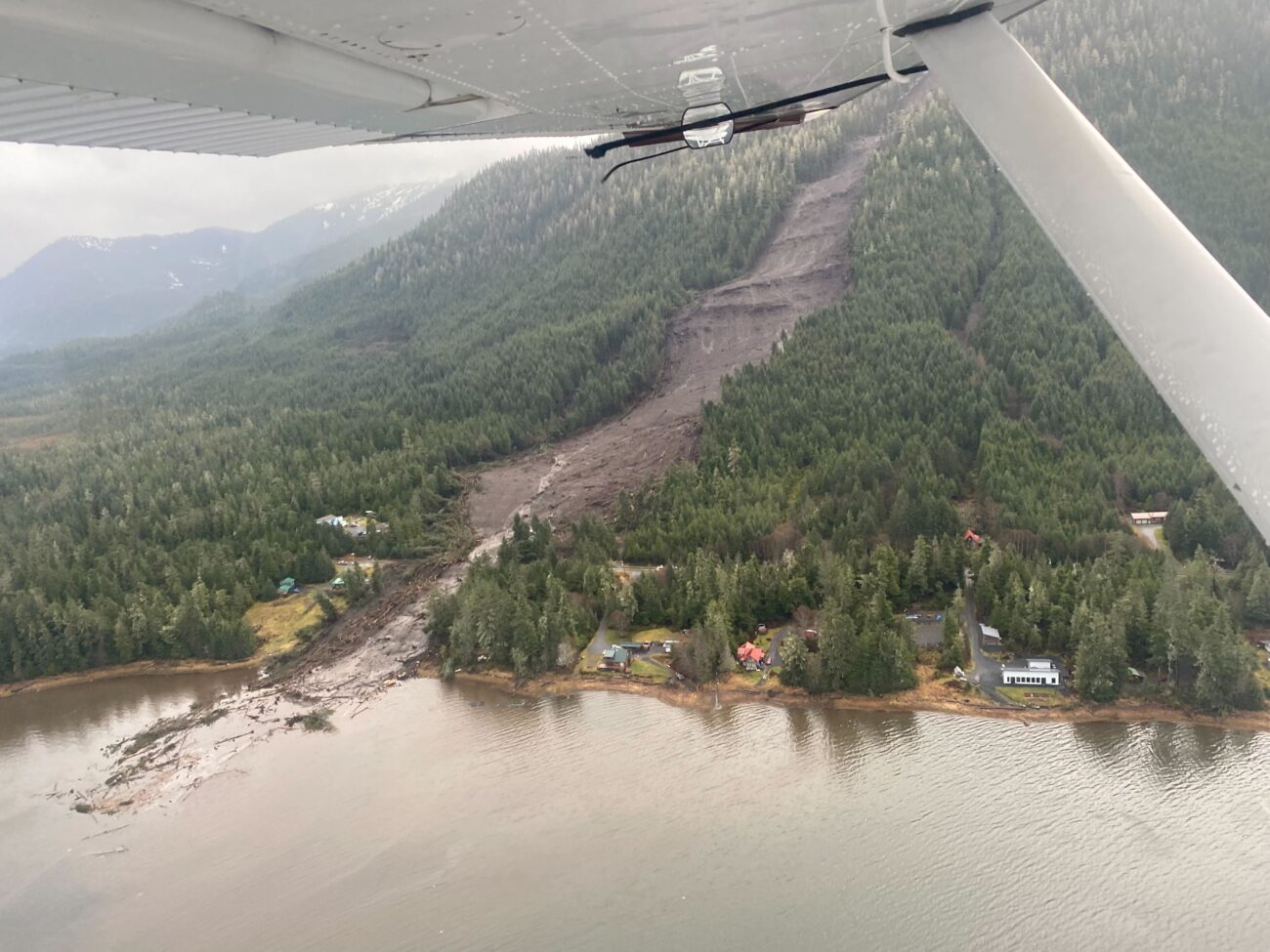
Wrangell’s Island experienced two large landslides the night of November 20th. Two smaller ones happened around the same time, but experts don’t know exactly when. One of the big ones took out two homes and damaged several structures along the highway about 11 miles south of town.
Mort Larson is with the state’s landslide hazards program with the Alaska Division of Geological and Geophysical Surveys.
He said for their report, a team of three geologists gathered data on all the slide sites as well as other areas of concern on the island.
“We went back and forth of how we wanted publish this, get this out to the right hands and make sure we’re presenting this data (it’s a factual data piece) correctly to the people,” Larson said.
Lots of rain –possibly four inches within 24 hours– mixed with wind likely caused Wrangell’s landslides. It’s similar to what caused deadly landslides in Haines and Sitka in recent years.
“Slopes get oversaturated and you got more rain systems coming in,” Larson said. “That’s usually one of the key triggers that really kind of get these things moving and that’s what we’ve seen there in Haines, that’s what we saw in Sitka.”
Microclimates and landslide complexities
There’s a complexity on landslide nomenclature and science. A couple examples of other landslides can be deep seated rotational landslides, where the debris goes into the bedrock and rotates the whole block. There’s also translational landslides, which happens when the debris moves along a planar, or flatter surface on a slope, with little rotation.
Those particular slides are known as debris flow because they were shallow landslides.
The National Weather Service in Juneau recorded normal amounts of precipitation before the fatal slide, except for the last six hours. In the 24 hour period preceding the landslide, 2.23 inches of rain were recorded at the Wrangell airport. Just over an inch of that happened in the last six hours before the slide.
“It’s hard to really predict”
Interestingly, during the same 24-hour time frame, Petersburg, about 30 miles to the northwest, received more than four inches of rain. So why did Petersburg not experience a landslide that night?
It could be because of microclimates or small pockets of weather happening within a weather system. It means that there could be different amounts of rain happening in different areas of the same island.
“In Petersburg, the geology is a little bit different,” Larson said. “The slopes are different, right? The surrounding community in Petersburg, their slopes are a little more gentle. It’s hard to really predict exactly what’s going to really kind of trigger those off. Have those slopes in Petersburg not been as saturated as much as the ones they’re in Wrangell? We don’t know.”
Although Petersburg didn’t experience a landslide that fateful November night, Prince of Wales Island southwest of Wrangell and Petersburg, had many.
The weather service gathers data, like rainfall, from the same spots throughout the region – often at community airports. But the weather in the nearby mountains could be much different. The rainfall recorded in Wrangell was at the airport, which is on flat ground, ground about 12 miles away from the slide area.
After Wrangell’s slides, the state Department of Transportation installed a rain gauge near the slide site.
Geologists noticed that the gauge measured up to twice the amount of rain that was recorded at the airport. This could mean that more than four inches of rain may have fallen during the 24 hours preceding the landslide events.
Landslide details
The report shows that at least two landslides occurred during the night of November 20. The largest at mile point 11.2, which was approximately 3,750 feet long – from the head scarp to the shoreline. That’s close to three quarters of a mile. An additional 500 feet stretched into the Zimovia Strait – about half a cruise ship long. It had a width that began at 100 feet and ended at 350 feet.
Scientists also found that two smaller landslides occurred just south of mile marker 11.2, based on LiDar (Light Detection and Ranging) monitoring.
All of the landslides consisted of minimal rock material, saturated soils and large wood debris. The LiDar monitoring showed that three of them released more material than what they deposited at their ends. This is common for landslides that end up in the water. Only one landslide, at 11.2, deposited in the water though.
The report states that the “volume may have been lost as a thin layer of mud spread across the ground.” There are many gullies that the vegetation could have ended up in as well for one of the slides.
Just one had the same amount of erosion to deposition, which is more common with landslides. Basically, the amount lost at the starting point of a slide and along its route is most likely to end up at the end of the slide.
The Middle Ridge Road landslide, which also occurred on November 20, was close to 150 feet wide (about nine parking spaces) and covered roughly 600 feet of the road. It stretched 3,600 feet long.
Additionally, the geologists found sand and sediment deposits along a channel and powerline above the Nugget Trailer Court at mile point three. A previous landslide deposited rocks and sediment along this area in 2021 or 2022.
The report states that multiple stream channels (potentially from the previous landslide) directed the water flow to the trailer park following the heavy rains on November 20.
“Our climate is changing”
Plans are in the works for better landslide monitoring for Wrangell. Since the slide, the state has been using remote sensing known as LIDAR to better understand the geography of the island. DGGS and the community is looking for federal funds for a landslide hazard program. Larson said then the local City and Borough, along with the the state’s Division of Geological and Geophysical Surveys, could collaborate on creating two maps – a landslide susceptibility map and a landslide inventory map
“The great piece about that and where we can jump ahead on that is that we just had recently LiDar collected for the entire island,” he said. “That is a key piece for doing these maps. You can’t do them with that if we didn’t have LiDAR, we’d have to go seek funding to get LiDar.”
If approved, they would receive the funds in September and map out parts of the island.
Southeast islands are covered in forested steep mountains. Larson said that he’s seen a pattern with these landslides in the region over the last eight years. He said with the steep slopes and the shallow soil that sits on them, they’re likely to continue.
“Our climate is changing,” he said. “We’re getting these big moisture patterns that are coming in these atmospheric river systems that just pummeled Southeast. So they’re going to continue. These are not going to stop and based on the terrain and the geology that we live here in Southeast, a lot of these communities are up against steep terrain, and ocean and water on the other side.”
He said their goal is to evaluate and understand where landslides occur, collect the data, map it out and give the information to decision makers and communities.
Two hundred and fifty two landslides on Wrangell Island alone
Wrangell’s interim borough manager, Mason Villarma, said he appreciates the help from the state’s Department of Natural Resources and its geology team.
“It took a lot of time to draft the report,” Villarma said. “We’re really lucky to have the relationship we do with DNR. It’s just the objective facts and circumstances around the conditions that were present pre and post slide that are most interesting.”
Landslides have been happening throughout Southeast Alaska for thousands of years. Between 1998 and 2010, the U.S. Forest Service mapped landslides within the Tongass National Forest. They found 252 landslides – or debris flows – just on Wrangell Island alone.
Those facts don’t make them any less devastating when one happens in your backyard.


